Email article
 Artificial intelligence is helping Facebook map population density. The social media platform has been using image recognition technology to produce population density maps of where people stay and how their Internet connections are affected. The principles of artificial intelligence can help Facebook map population density. Facebook’s pursuit to focus on the 10% of the world that has been denied Internet access is highly commendable. This project has been led by Facebook’s Connectivity Lab, the technical arm that is into research and development with drones, satellites and lasers to find new ways of making Internet available in remote areas, rural areas and developing countries. The research aim was to determine what kind of equipment would be best for serving rural and remote areas, such as satellite, cell towers, or drones.
Teams that helped generate the Maps
The innovative project that helped Facebook to map population density was executed in collaboration with a number of Facebook teams. The different teams involved in the research included the Core Data Science team that dealt with handling huge volumes of data and machine learning, FAIR and the Applied Machine Learning teams that were assigned the task of development of internal tools that helped in the smooth flow of the project and the Infrastructure team that provided the resources to perform the analysis of the huge volumes of data at the lightning speed of less than two weeks.
How Maps were generated by Facebook to map population density
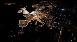
The teams analyzed high-resolution satellite imagery and a version of Facebook’s own facial recognition software to identify human-built structures. These helped to identify areas where people lived. Using this, they created a population dataset for 20 countries covering an area of 21.6 million square kilometers, which was about 350TB of data. Analysis was done using 14.6 billion images. This is about ten times more than the images analyzed by Facebook on a day to day basis. Using these images, maps were generated that helped Facebook to map population density.
Challenges faced during the study
Carrying this process to a global level was a huge challenge that the teams faced. Though the principles of machine learning and artificial intelligence helped Facebook to map population density, identifying buildings in rural areas was a huge problem. Since 99% of the landmass that was analyzed was without any buildings, it was a challenge for the artificial intelligence and machine learning techniques to identify man-made structures.
Uses of population distribution maps
In addition to identifying the areas that lack Internet access facilities and the technology to be used in an area, information obtained from population distribution maps can be used by urban planners to improve the conditions of roads and other public infrastructure. They can also be used during an emergency for crisis mapping for aid workers. Further, maps generated by Facebook to map population density can help epidemiologists to map outbreaks of epidemics, predict the spread and develop precautionary control measures. Facebook, in collaboration with Columbia University is planning to create a public data set that could provide information to governments, scientists, financial industries, technical companies, the business community and the like about where people live and map the future.
With the help of the maps generated by Facebook to map population density, the world simultaneously becomes a smaller yet a larger place.